As part of our Community Photographic Exercise, we would love for you to share a couple of images that may be included on the blog. To have these uploaded to the blog, simply attach them in an email and send to grampianslandscape@gmail.com.
Please include a comment or caption that explains why this landscape is significant to you, or how it has been spoiled. We can include your name, however please let us know if you wish to remain anonymous.
If you wish to create a post to be included on the blog, please express your interest by emailing the above address.

Thursday, 4 August 2011
Wednesday, 3 August 2011
Community Photographic Exercise
To gain a better understanding of the community's perceptions and values about what the significant landscapes of the Southern Grampians Shire are, an interactive community photographic exercise is currently underway.
You are invited to participate by submitting a photo of your favourite Grampians view, and a photo of what you would not like to see in the landscape. This information will help us in mapping key view lines and look outs, and planning for sensitive development in the landscape. The photo exercise runs until Friday 2 September.
Details about the photo exercise are provided in the instruction sheet which can be viewed in larger format by clicking on the images below:


The instruction sheets are also available in a printable format on the Southern Grampians Shire project webpage:
http://www.sthgrampians.vic.gov.au/Page/Page.asp?Page_Id=1704&h=0
.
Southern Grampians Field Survey
The Planisphere consultant team would like to share some of the wonderful scenery we encountered while on survey for the Significant Landscape Assessment:

Dunkeld Primary School

Red Gum at Sunset

Mirranatwa

Coleraine-Balmoral Road

Victoria Valley

Dunkeld Primary School

Red Gum at Sunset

Mirranatwa

Coleraine-Balmoral Road

Victoria Valley
Eugene von Guérard Exhibition
Thank you to Keith Staff who has brought to our attention an exhibition of the work of Eugene von Guérard, one of Australia's great colonial landscape painters who drew much inspiration from the Grampians landscape.
Below is a very special painting of the Southern Grampians from the top of Mt. Rouse, completed by Von Guerard in 1861:

The original will be on display along with other paintings of the Grampians and volcanos of the Western District at the Ian Potter Centre, NGV Melbourne, until August 7th.
For more information, check out their website:
http://www.ngv.vic.gov.au/whats-on/exhibitions/exhibitions/eugene-von-guerard
Community Workshop
Thank you to every one who came along to the Community Workshop in Cavendish on 16 June. It was great to meet everybody and to learn about what aspects of the landscape are valued the most, what threats there are to it and what members of the community would like the study to achieve..

On the night, groups were formed around tables and a number of questions were used as a basis for discussion. Some of these and the responses are listed below:
What words best describe the landscape?
Majestic, unique, rugged, rolling, ancient, fertile, diverse, bucolic, dramatic, atmospheric, naturally rich, fragile, healthy and ever-changing. The iconic nature of the landscape, its importance to Australian and Aboriginal cultural heritage, and the fact that it is also a working, productive landscape were key themes that were discussed.
Where would you take an interantional visitor to appreciate the landscape?
Halls Gap, through Mirranatwa Gap to Bryan Swamp
Victoria Valley, Dunkeld and Rocklands Reservoir
To the railway bridge over Wannon River
Mt. Eccles, Strachan's Hut and fishing at Moora Moora Reservior
Mt. Rouse, and the volcanic features, natural springs, caves and wetlands
To see the aboriginal rock paintings, and sites with a variety of flora and fauna
What areas/aspects of the landscape are the most significant?
The way the mountains jump out of the plains
The wetlands and swamps
Seeing the productive, agricultural landscape in action
The drama, scale and impact of the mountains on approach
Lifestyle amenity
The way the Grampians create their own climatic conditions
Strachan's Hut on the north side of the Glenelg River has its own ecosystem, there is no sun after midday and the stringybark rain forest is unique
The sculptural qualities and proliferation of the red gums
The fragility of the landscape, it is irreplaceable
What are the key threats to the landscape?
Inappropriate industrial development, unplanned development, population growth with the pressures it places on infrastructure and subdivision, loss of productive agricultural land, plantations of the wrong species and wall-to-wall plantations, litter, fire and a lack of protection for wildlife and vegetation were all identified.
Do you have any concerns about the study, and what would you like it to achieve?
Things, change and there is a need to change with it, restrictions on farming and business activities may hinder this
Community values are important, getting the community aware and involved, and listening to the people is an integral part of the study
There needs to be transparency in the process, it needs to be made clear how conclusions have been reached
The landscape must be preserved for future generations, we need to look to the future rather than prioritising short term goals
We need to create awareness of the landscape, for locals and tourists, to ensure that it is not taken for granted
The study should be done for the whole of the Shire
It needs to be made clear that the study is not going to restrict development, rather that it will identify the places that are the most suitable
We understand that not everybody who would like to contribtute to the Study were able to attend the Community Workshop. The study area is quite broad, and this blog has been established to create access for everybody to have a say and assist in developing the outcomes of the study.
If you have anything you would like to add to the discussions above, or any other input, please feel free to contribute by commenting on this post.
Thursday, 26 May 2011
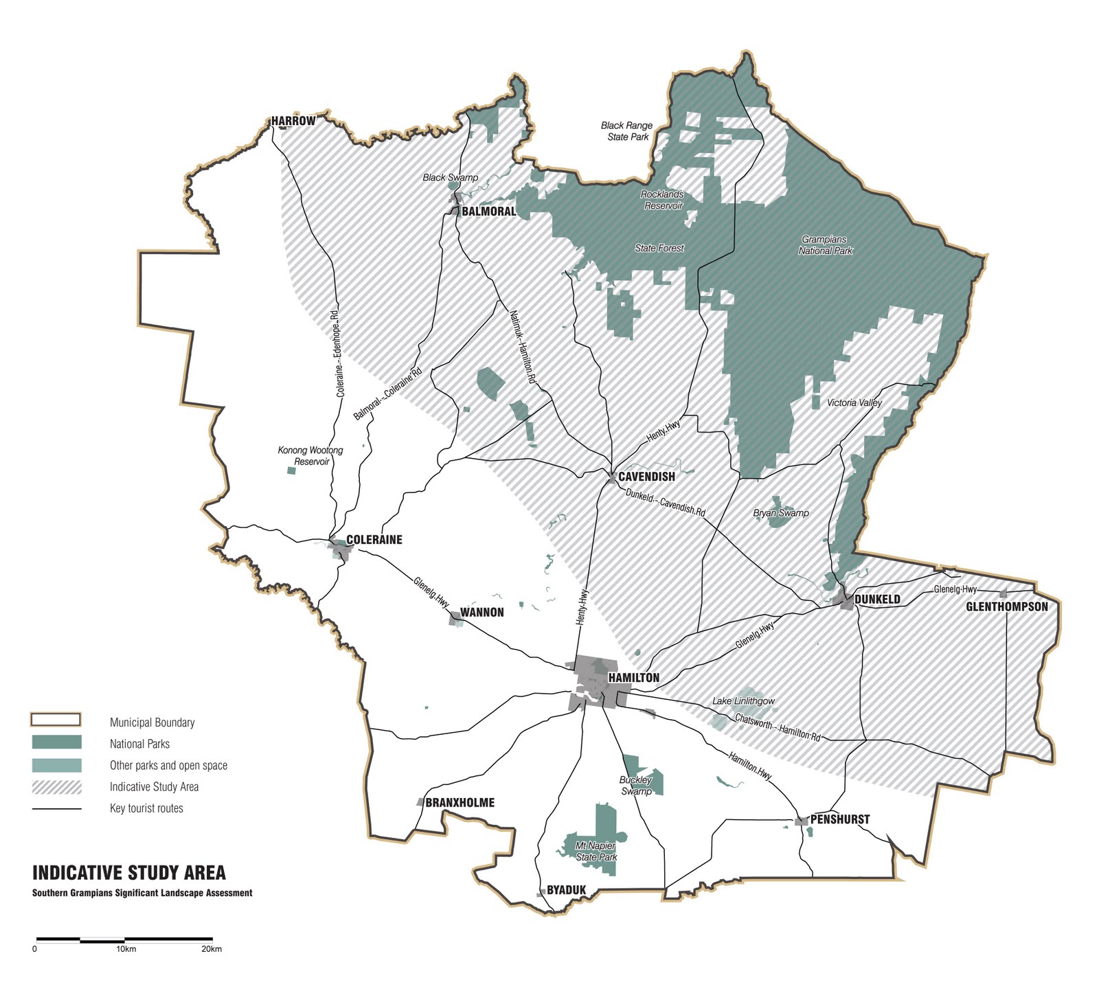
Preliminary Study Area
The Study Area is the surrounds of the Grampians National Park, but is expected to vary due to topography, landscape features and views, and will therefore be clearly defined at the beginning of Stage 2 of the project. At this stage, an indicative study area of 20km radius from the national park boundary has been defined as the preliminary study area.

Project Contact Details
To send in images to be shared on this blog, attach them to an email and send to: grampianslandscape@gmail.com
Be sure to include a caption with each image to let us know why it is important to you! We will include this below each image.
Council Website
Southern Grampians Shire Council has dedicated a page to the project on their website.
For all information and updates about the project check the webpage by using the following link:
www.sthgrampians.vic.gov.au/Page/Page.asp?Page_Id=1704&h=0
To register your interest with recieving regular updates on the progress of the project, or if you have any queries contact:
Tom Scholfield
Senior Strategic Planner
Ph: 03 5573 0218
Email: tscholfield@sthgrampians.vic.gov.au
Subscribe to:
Posts (Atom)